
Leadville, Colorado is an awesome escape from the summer heat, and is a totally overlooked leaf-peeping destination. But 10,000 feet of elevation makes hiking and trail running a LOT more difficult, particularly if you’re trudging up the side of a mountain. I used to think the only beginner-friendly options were simply running around town (which is honestly still quite hilly). That is, until I got some local insight (thanks @scoutycowdog!).

Interlaken, Turquoise Lake, South Elbert, and parts of the Colorado Trail near Camp Hale are lovely, rolling paths with beautiful water and mountain views. Interlaken and Turquoise Lake can get busy on summer weekends, but overall, you’ll have way less crowds than many places in Colorado.
I spent about two hours hiking each trail, one with an 18-pound baby in a backpack, and covered between two and five miles fairly easily (my legs were tired afterward but the hikes themselves were manageable!).
This blog was originally written during the coronavirus pandemic. Please follow local and CDC travel and safety guidelines to be respectful and stay safe. I am not a public health official, but I do urge you to get vaccinated, particularly if you are traveling. Vaccines are safe, effective, and the best way to prevent more people dying from COVID-19.
Are Interlaken and Turquoise Lake basically the same hike?
Yes and no. Both are (relatively) flat trails along a lake that is bordered by stunning mountains. They are both out-and-back trails, meaning you walk to a certain point and then turn around and come back the same way.
(Turquoise Lake is technically a loop, but it’s more than 10 miles around, so I assume you’re not doing the entire loop!)
There are differences between the two trails, though, which is why I enjoyed doing both of them.
Turquoise Lake Trail

Turquoise Lake is almost totally flat. There is easier beach access. It’s basically right in town. You will see more people because the trail goes along some campgrounds and crosses the parking lot for the boat ramp. The road to get there is significantly easier to drive on. This hike is pick-your-own length. Just walk as far as you want to go and then turn around!
Interlaken Lake Trail
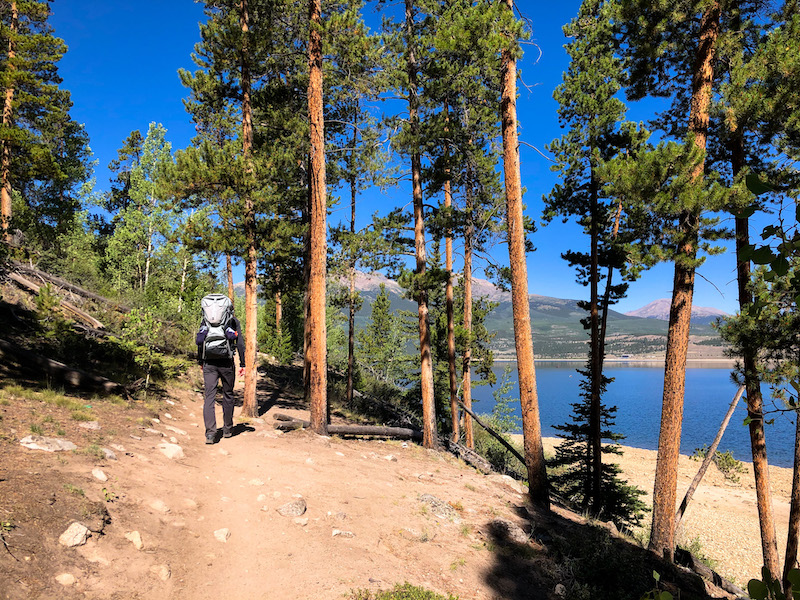
Interlaken is 20 minutes outside of Leadville. It’s hillier. The access road requires a higher-clearance vehicle (our Forester was fine). There’s a very cool historic site that you hike to (the old Interlaken resort). And just beyond that is a meadow with absolutely stunning views of the surrounding peaks (the featured image at the top of this post is from that meadow). If you walk to this meadow and back, it’s just under five miles. It took us just over two hours.
What are South Elbert and Camp Hale like?
Both trails are excellent leaf-peeping spots, but their panoramic mountain vistas would make them great options year-round, too.
Both trails are great options for choose-your-own adventures since they go on for miles. The Colorado Trail goes all the way to Denver, after all! Simply hike as far as you want to and turn back when you’re tired or the trail gets too steep. This has come in handy for trips with in-laws traveling from sea level as well as letting Baby OB (now toddler OB) learn to hike on their own. (When a melt-down happens, we can just turn back for home!)
South Elbert Trail

Mt. Elbert is a “14-er,” or a peak that goes over 14,000 feet high. Mt. Elbert is actually the second-highest peak in the continental United States, so I’m obviously not recommending you hike all the way up. The southern trailhead is across Twin Lakes from Interlaken and takes you through a large aspen grove with multiple panoramic views of the mountains.
Colorado Trail at Camp Hale

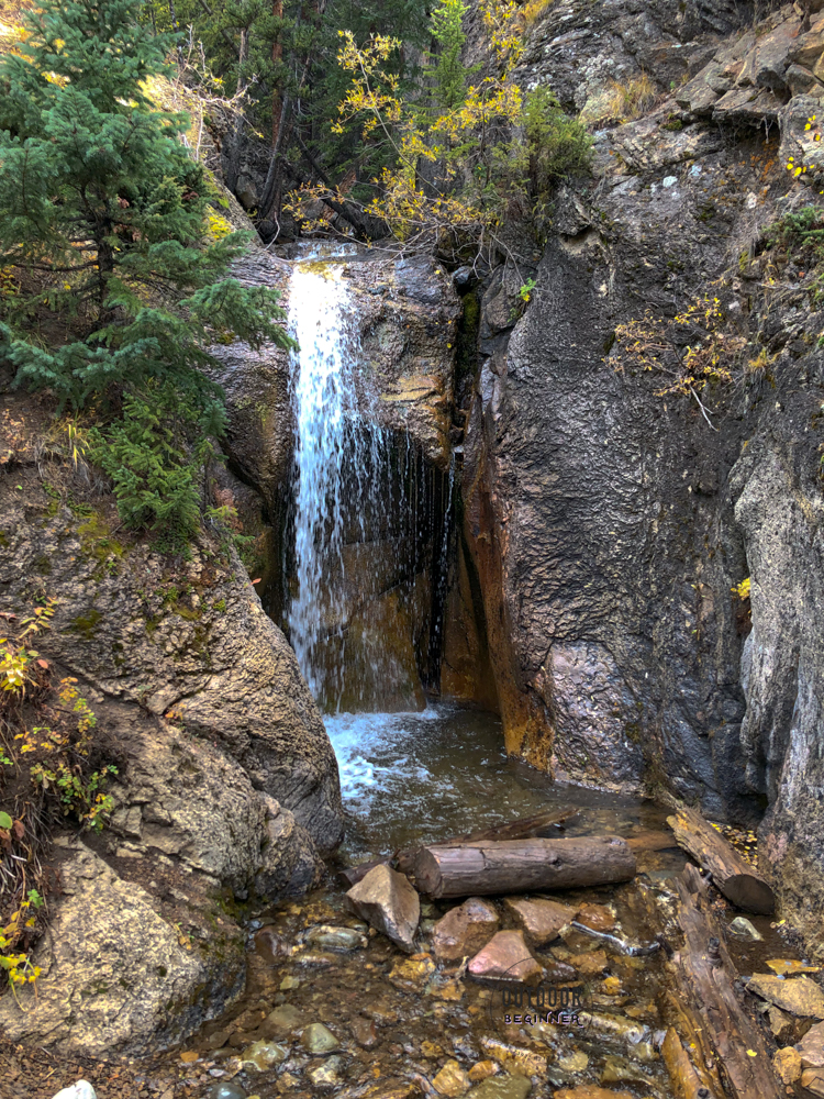
This portion of the Colorado Trail is almost completely flat, although if you want to hike up one steep hill (wouldn’t take more than 10-15 minutes if you take multiple breaks) you get a bananas pretty view of the nearby 10 Mile Mountain range.
If you don’t make it to the overlook, you still get great views (above) and a waterfall that’s flowing almost year-round. My friend’s nephew made it to the waterfall in socks and sandals, so it’s family-friendly too!
How do I get there?
Turquoise Lake Driving Directions
Turquoise Lake can be accessed from multiple points around town. We drove to the south end where Matchless Boat Ramp is, which was a 12-minute drive from in town. The road is paved the entire way and very easy to drive on. If there are parking spots available along Routes 4, you can also park there to access the trail.
If you’re leaving from the boat ramp, head to the north side (to the right if you’re facing the lake) and you’ll see the trail heading out from that end of the parking lot.
Interlaken Driving Directions
The Interlaken trailhead is 20 minutes outside of Leadville in Twin Lakes. The drive is on paved, flat roads until the last half-mile when you get off of the main road into Twin Lakes. The road gets very hilly and rocky, and I wouldn’t recommend driving it in a car with low clearance.
Alternatively, you can add a half-mile onto your hike and park in the lot on Route 25, which is easily accessible by any car (but still requires driving a short distance on a dirt road).
South Elbert Driving Directions
The South Elbert Trailhead is a 25-minute drive from Leadville on both paved and unpaved roads. Highway 24 is almost completely flat, and County Road 10 is a well-maintained gravel/dirt road that does not require four-wheel drive or a high-clearance vehicle. It’s an easy drive!
Camp Hale Colorado Trail Driving Directions
You’ll drive up and over Tennessee Pass on paved roads before taking well-maintained dirt/gravel roads through Camp Hale. Tennessee Pass doesn’t have any steep drop-offs, and like South Elbert, this is an easy drive in any vehicle! This trail is about 30 minutes north of Leadville. Navigate here >>
Where do I go?
Turquoise Lake Trail Directions
Turquoise Lake has just one trail that goes around the lake, so it’s not hard to find or stay on. Because of all the beach access, there are a lot of meandering social trails down to the shore, but they all hook back up to the main nature trail.
The only point that was truly confusing was when there was actually a sign for the trail near the campgrounds. It pointed away from the lake but said that the nature trail continued that way. We walked a short ways in that direction before realizing it was definitely the wrong way. Maybe it led back to one of the campgrounds? Regardless, when in doubt, stick close to the lake and you can’t go wrong. Here is my route >>
Interlaken Trail Directions
The Interlaken Trail runs along the Colorado Trail and the Continental Divide Trail, so there are a few intersections along the way. There’s only one way to go from the parking lot, so getting started is easy. There are a few forks for the Colorado Trail or Continental Divide Trail, but stay to the right and you’ll be headed the right direction. This is also considered the Collegiate Peaks East segment, so follow signs for that when they pop up.
Make sure to keep walking past the first historical building you see. This is the Dexter Cabin; I thought it was the actual hotel and was ready to turn around. Not only is the second site where the Interlaken Hotel is very cool, but if you walk just past that, you hit a meadow with absolutely spectacular views (see the image at the beginning of this blog post). Don’t turn around early and miss it! Here is my route >>
South Elbert Trail Directions
There’s only one option from the parking lot, which makes it easy! The only junction in the first two miles is a fork shortly after you start the trail; make sure you stay straight on the right side of the fork. It’s a very straight-forward, obvious trail to follow. Turnaround whenever you’ve had your fill! Here is my route >>
Camp Hale Colorado Trail Directions
This trail is super easy to follow since it’s the only one for miles. The waterfall is a little less than one mile from where you park. If you continue past that point, there is a fork toward another parking area (you can also start here if you’d like for a super shorty hike).
We hiked up the one steep part to get to an overlook, but if that’s too much for you, just skip it! Here’s my route >>

What is the trail like?
Turquoise Lake has almost zero rocks and very little elevation change on a wide, dirt path. There’s one very small hill just south of the boat ramp, and one or two spots with some roots sticking out. There were two downed trees across the trail as of August 2020. One that you had to limbo under and the other that you had to step over. Both were manageable, although I had a baby in a backpack on, so limbo-ing required some guidance from my husband and liberal use of my hiking poles to stay upright!
Interlaken has three hills that are steep but short. Even if you take a lot of breaks, they wouldn’t take more than 3-5 minutes to get up. You’ll be hiking up them on your way back, so you’ll be going downhill on the way out. The hills are the rockiest parts, and otherwise the trail is quite smooth. There are a few points where one side of the trail steeply drops off and slopes down into the reservoir, but the likelihood of you tripping, falling, and tumbling down the hill is slim to none.

South Elbert is a bit rockier, but still mostly dirt. The trail is wide enough to walk next to a toddler, but just barely. You’re hiking slightly uphill for the entire time out, so pace yourself!
Camp Hale is the narrowest of the trails, known as “singletrack.” You’ll be walking single file, except for the shmancy new bridge at the waterfall (see below). The hill up to the overlook I’ve mentioned is mostly rocks and loose gravel, so take your time going up and down!

What should I wear and bring?
Plenty of water! You’re at 10,000 feet, so it’s very very easy to get dehydrated or forget to drink enough water. I would define “plenty” as one liter per person.
I also recommend a hat, sunglasses, and liberally applied sunscreen. The sun doesn’t mess around at 10,000 feet! You’ll burn faster than you would at lower elevation. Find safer sunscreen on this website. I like this sunscreen from Thinkbaby (for adults and kids). If you have darker skin, it does leave a pretty significant cast, but I have heard good things about Black Girl Sunscreen.
I wore trail running shoes for all of these hikes, which was perfectly adequate. You can of course wear hiking boots if you have them! If you don’t have trail shoes, just regular sneakers will do but be careful going downhill since you have a little less traction. At no point will you be getting your feet wet, so don’t worry about that.
For more information on what you should bring hiking no matter what trail you’re on, read my previous post here.
Is it crowded?
You will definitely see other people and you won’t be by yourself. Interlaken and Turquoise Lake are significantly busier than South Elbert and Camp Hale (where seeing six people is considered SUPER busy).
The later in the day you go, the busier it gets at the more popular trails. When we hiked Interlaken, the mountain bike traffic also picked up significantly around 10:30 a.m.
Anything else I should know?
None of the trailheads have maps at them, so an app like AllTrails can be useful in keeping track of where to go. The paid version is less than $20 per year and lets you track where you are and download maps to reference offline, which I think is totally worth it to keep you from getting lost.
Turquoise Lake is the only one with a bathroom, which is at the boat ramp of Turquoise Lake. Try to hold it if you can, because you’re quite close to water sources at all the hikes. Leave No Trace ethics recommend getting at least 200 feet (half a football field) away from water, which is pretty difficult to pull off.
We didn’t see any wildlife while we were out, but being Bear Aware is always a must in Colorado. There are also people backpacking throughout the Colorado and Continental Divide trails, so if you stumble upon anyone’s campsite, be respectful!
